


Quick Facts
Location: Pender Harbour, Sunshine Coast, BC
Region: Mid Sunshine Coast
Time Needed: 1.5–2.5 hours
Admission: Free
Facilities: Small parking area, trail
Best Season: Year-round
Dog Friendly: Yes (on leash)
Info
Parking / Access
Small parking area at the trailhead. Can fill up on weekends—arrive early. Google Maps
Frequently Asked Questions
What is Pender Hill?
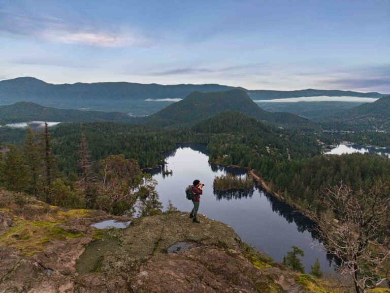
Pender Hill is a popular hiking destination near Pender Harbour on BC's Sunshine Coast. The moderate trail rewards hikers with 360-degree panoramic views of the surrounding islands, coastal waters, and mountains—one of the best viewpoints on the Sunshine Coast.
Where is Pender Hill located?
Pender Hill is located near Madeira Park in the Pender Harbour area of the Sunshine Coast, approximately 70 km from the Langdale ferry terminal.
How do I get to the Pender Hill trailhead?
From Langdale ferry, drive north on Highway 101 for approximately 70 km (1 hour). Turn onto Garden Bay Road near Madeira Park and follow signs to the Pender Hill trailhead.
How long is the Pender Hill hike?
The hike is approximately 2 km one way with about 210 m (700 ft) of elevation gain. Allow 45 minutes to 1 hour each way, or 1.5–2.5 hours round trip depending on your pace and time at the summit.
How difficult is the Pender Hill trail?
The trail is rated moderate. It has some steep sections but is manageable for most hikers with reasonable fitness. Sturdy footwear is recommended.
What can I see from the summit of Pender Hill?
The summit offers 360-degree panoramic views including Pender Harbour and its islands, the Coast Mountains, the Strait of Georgia, and on clear days, views extending to Vancouver Island.
Is the Pender Hill trailhead parking busy?
The small parking area can fill up on weekends and holidays, especially in good weather. Arrive early for the best chance at a parking spot.
When is the best time to hike Pender Hill?
Pender Hill is accessible year-round. Clear days offer the best visibility for views. Morning or late afternoon provides the best lighting for photography.
What should I bring for the Pender Hill hike?
Bring sturdy hiking shoes, water, snacks, layers of clothing, a camera, and sun protection. The trail can be muddy after rain.
Are dogs allowed on Pender Hill?
Yes, dogs are allowed on the trail but should be kept on leash.
Is there cell phone service on Pender Hill?
Cell phone service may be limited at the trailhead and on the trail. Don't rely on it for navigation.
What else is nearby Pender Hill?
Nearby attractions include Madeira Park for services and boat tours, the kayaking waters of Pender Harbour, and other trails in the area.


